
Service– category –
-
Protected: Orbital Net has begun research on color reproduction and super-resolution of SAR satellite images
この記事はパスワードで保護されています -
Protected: I have updated the content of the service page on the website.
この記事はパスワードで保護されています -
Protected: We have developed an algorithm to generate normalized building polygons from building segmentation images!
この記事はパスワードで保護されています -
Protected: We have released a demo of a super-resolution map using an image generation AI to enhance the GSI Tiles (annual aerial photographs) beyond zoom level 20.
この記事はパスワードで保護されています -
Protected: The content on the service page of the website has been updated.
この記事はパスワードで保護されています -
Protected: “Automatic High-Strength Bolt Tightening Inspection Service Evaluation Version”
この記事はパスワードで保護されています -
Protected: Published a QGIS plugin on GitHub that could be useful for professional tasks.
この記事はパスワードで保護されています -
Protected: We have uploaded a video for our exhibition at the AI & Artificial Intelligence EXPO to YouTube
この記事はパスワードで保護されています -
Protected: Applied Co., Ltd. has started selling our company’s “Satellite Image and Aerial Photo Image Analysis Solution ‘Geo Detector’ Recommended PC.”
この記事はパスワードで保護されています -
Protected: We have released the “3D Visualization Map of Buildings with Solar Panel Installations” using PLATEAU.
この記事はパスワードで保護されています -
Protected: We have released the QGIS plugin.
この記事はパスワードで保護されています -
Protected: We have uploaded a demo video of the extraction of rooftop solar panel shapes to YouTube.
この記事はパスワードで保護されています -
Protected: I have developed a web-based business support system for local governments (fixed asset operations).
この記事はパスワードで保護されています -
Protected: We have released a brochure for our Feature Interpretation Solution
この記事はパスワードで保護されています -
Protected: Here is a summary of the AI-related initiatives from the previous term
この記事はパスワードで保護されています -
Protected: We are pleased to announce that the ‘Verification Report on the Technological Development Results of Aerial Laser Bathymetry’ that our company has been actively working on has been published on the Ministry of Land, Infrastructure, Transport and Tourism’s Geospatial Information Authority of Japan website.
この記事はパスワードで保護されています -
Protected: The content has been added
この記事はパスワードで保護されています -
Protected: We have added the following content page under the category
この記事はパスワードで保護されています -
Protected: We have added a page on AI × Geospatial Applications: Building Shape Extraction and Polygonization.
この記事はパスワードで保護されています -
Protected: We have added new content
この記事はパスワードで保護されています -
Press Release on “Technology Development Contributing to the Improvement of Accuracy and Work Efficiency in Airborne Laser Bathymetry
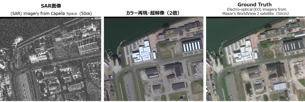
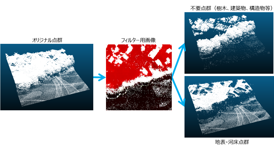
Announcement of Press Release on "Technology Development Contributing to the Improvement of Accuracy and Work Efficiency in Airborne Laser Bathymetry" by the Ministry of Land, Infrastructure, Transport and Tourism We are pleased to infor... -
Protected: We have released a demo video showcasing object tracking using deep learning (Traffic Counter). The video was updated on September 20, 2019.
この記事はパスワードで保護されています -
Protected: We have released a video demonstrating the detection of migrating sweetfish (ayu) as an example of object detection using deep learning
この記事はパスワードで保護されています -
Protected: “Orbital Vector Tile Map” Trial Launch
この記事はパスワードで保護されています -
Protected: We will end the trial release of the vector tile map.
この記事はパスワードで保護されています
1